Facts & Statistics
| STATE STATISTICS | |
| Population 2020 |
5,657,342 |
| Population 2019 | 5,640,053 |
| Population 2018 |
5,611,179 |
| Population 2017 | 5,568,155 |
| Population 2016 | 5,523,409 |
| Below Poverty 2019 | 9 |
| Below Poverty 2018 | 7.9 |
| Below Poverty 2017 | 9.5 |
| Below Poverty 2016 | 9.9 |
| Employment – Population Ratio 2019 | 68 |
| Employment – Population Ratio 2018 |
67.8 |
| Employment – Population Ratio 2017 | 67.8 |
| Employment – Population Ratio 2016 | 67.6 |
| Unemployed 2020 | 4.4 |
| Unemployed 2019 | 3.1 |
| Unemployed 2018 | 2.9 |
| Unemployed 2017 | 3.4 |
| Unemployed 2016 | 3.9 |
| Foreclosure Rate 2018 | 1 of 3,821 |
| STATE FACTS |
|---|
| The Mall of America in Bloomington is the size of 78 football fields – 9.5 million square feet. |
| Minnesota’s waters flow outward in three directions: north to the Hudson bay in Canada, east to the Atlantic Ocean, and south to the Gulf of Mexico. |
| Minnesota has 90,000 miles of shoreline, more than California, Florida and Hawaii combined. |
Government
| ELECTED OFFICIALS | |
| Governor |
Tim Walz (DFL) |
| Lieutenant Governor | Penny Flanagan (DFL) |
| Attorney General | Keith Ellison (DFL) |
| Secretary of State | Steve Simon (DFL) |
| State Senate Control | R – 34; D – 31 |
| State House Control | DFL – 70; R – 64 |
Legislative Process
| LEGISLATIVE DATES AND DEADLINES | |
| Convenes | January 8, 2019 |
| Sine Die Adjournment | May 20, 2019 |
| Committee Action Deadlines | N/A |
| Crossover Deadline | None |
| Carryover from Previous Session | No |
| Governor’s Signing Deadline (in session) | Three days, Sundays excepted |
| Governor’s Signing Deadline (after adjournment) | 14 days from presentment, or legislation is pocket vetoed (even years) |
| Veto Override | 2/3 majority |
| Legislation Effective Date | August 1 following enactment |
Notable Laws & Legislation
SAFE Act
- MN HF 2123 (now Minn. Stat. Banking: s. 47, subs.: Reverse Mortgage Loans and Consumer Small Loans; and s. 58)
- MN SF 2510 (now Minn. Stat. Banking: c. 58A)
Security Breach Notification Law
Enforcement
Consumer Complaints
Regulatory Actions
Featured Regulations
Regulatory Guidelines
Statutes of Interest
Advocacy, Initiatives & Reports
Advocacy
- 33 States Amicus Brief re: Telephone Consumer Protection Act (March 2020)
- 23 State & DC Letter to FDIC re: “Rent-A-Bank” Predatory Lending (February 2020)
- 25 State & DC Letter to Education Department re: Student Loan Debt Relief (February 2020)
- 23 State & DC Amicus Brief re: Constitutionality of CFPB (January 2020)
- 21 State & DC Letter to OCC re: “Rent-A-Bank” Predatory Lending (January 2020)
- 19 State & DC Letter to Congress re: Education Department Borrower Defense Rule (January 2020)
- 20 State & DC Amicus Brief re: Public Student Loan Forgiveness (November 2019)
- 22 State Letter to Education Department re: Student Loan Forgiveness (November 2019)
- 29 State & DC Letter to Education Department re: Student Loan Fraud (October 2019)
- 12 State & DC Letter to CFPB re: Home Mortgage Disclosure Act (October 2019)
- 20 State & DC Letter to Congress re: Cannabis Banking (September 2019)
- 27 State & DC Letter to CFPB re: Debt Collection Rule (September 2019)
- 31 States & DC Amicus Brief re: Student Loans (August 2019)
- 50 States & DC Letter to FCC re: Robocalls (August 2019)
- 24 States & DC Letter to CFPB re: Overdraft Rule (July 2019)
- 40 States & DC Letter to FTC re: Data Privacy (June 2019)
- 50 States & DC Letter to Education Department re: Student Loans for Disabled Veterans (May 2019)
- 24 States & DC Letter to CFPB re: Payday Rule (May 2019)
- 33 States & DC Letter to Congress re: Marijuana Banking (May 2019)
- 41 States & DC Letter to FCC re: Robocalls (May 2019)
- 20 States & DC letter to Education Department re: Student Loan Disclosure to Law Enforcement (April 2019)
- 24 State & DC Letter to CFPB re: Payday Lending Rule (March 2019)
- 50 States & DC Letter to U.S. Senate Committee on Commerce, Science & Transportation re: Robocalls (March 2019)
- 30 States & DC Letter to FTC re: Identity Theft Rule (February 2019)
- 22 State AGs Letter to CFPB re: Regulatory Sandbox (February 2019)
- 15 State AGs Amicus Brief re: Tribal Immunity for Payday Lending (December 2018)
- 43 State AGs Letter to Social Security Administration re: Identity Fraud (December 2018)
- 15 State AGs Amicus Brief re: Tribal Immunity for Payday Lending (December 2018)
- 43 State AGs letter to Social Security Administration re: Identity Fra0ud (December 2018)
- 14 State AGs letter to Office of the Comptroller of the Currency re: Community Reinvestment Act (November 2018)
- 21 State AGs letter to Department of Education re: closed-school loan discharge regulations (October 2018)
- 17 State AGs letter to HUD re: Affirmatively Furthering Fair Housing rule (October 2018)
- 35 State AGs letter to Federal Communications Commission (FCC) re: Robocalls (October 2018)
- 16 State AGs Amicus Brief re: States’ Oversight on Student Loan Servicers (September 2018)
- 14 State AGs letter urging CFPB to continue enforcing the Equal Credit Opportunity Act’s disparate impact liability provision (September 2018)
- 17 State AGs letter urging HUD not to undermine the Agency’s Fair Housing Act (FHA) disparate impact regulations (August 2018)
- 20 State AGs letter urging Secretary of Education to share student loan information with law enforcement (July 2018)
- 20 State AGs letter to Congress opposing valid-when-made legislation (June 2018)
- 14 State AGs letter urging CFPB to retain public database of consumer complaints (June 2018)
- 16 State AGs letter urging the Trump Administration to respect the CFPB’s investigative authority (April 2018)
- 20 State AGs letter to Congress regarding proposed FDCPA amendments (April 2018)
- 32 AGs letter urging Congress to preserve state’s authority to enforce data breach & security laws (March 2018)
- 30 AGs letter to Congress urging it to reject legislation that would block state oversight of student loan servicing industry (March 2018)
- 20 State AGs letter to Education Secretary re student borrower defense proposal (March 2018)
- 16 State & DC AGs brief calling on Trump Admin. to respect CFPB independence (February 2018)
- 16 State AGs letter to President re CFPB (December 2017)
- Lawsuit opposing temporary CFPB director (December 2017)
- 36 State AGs Letter 1 and Letter 2 – Credit Freeze Fees (October 2017)
- 43 State AGs letter – Major Data Breach (September 2017)
- 31 State AGs letter to CFPB – Debt Collection Rules (March 2014)
Reports
Trade Associations
Minnesota Financial Services Association


Political Geography
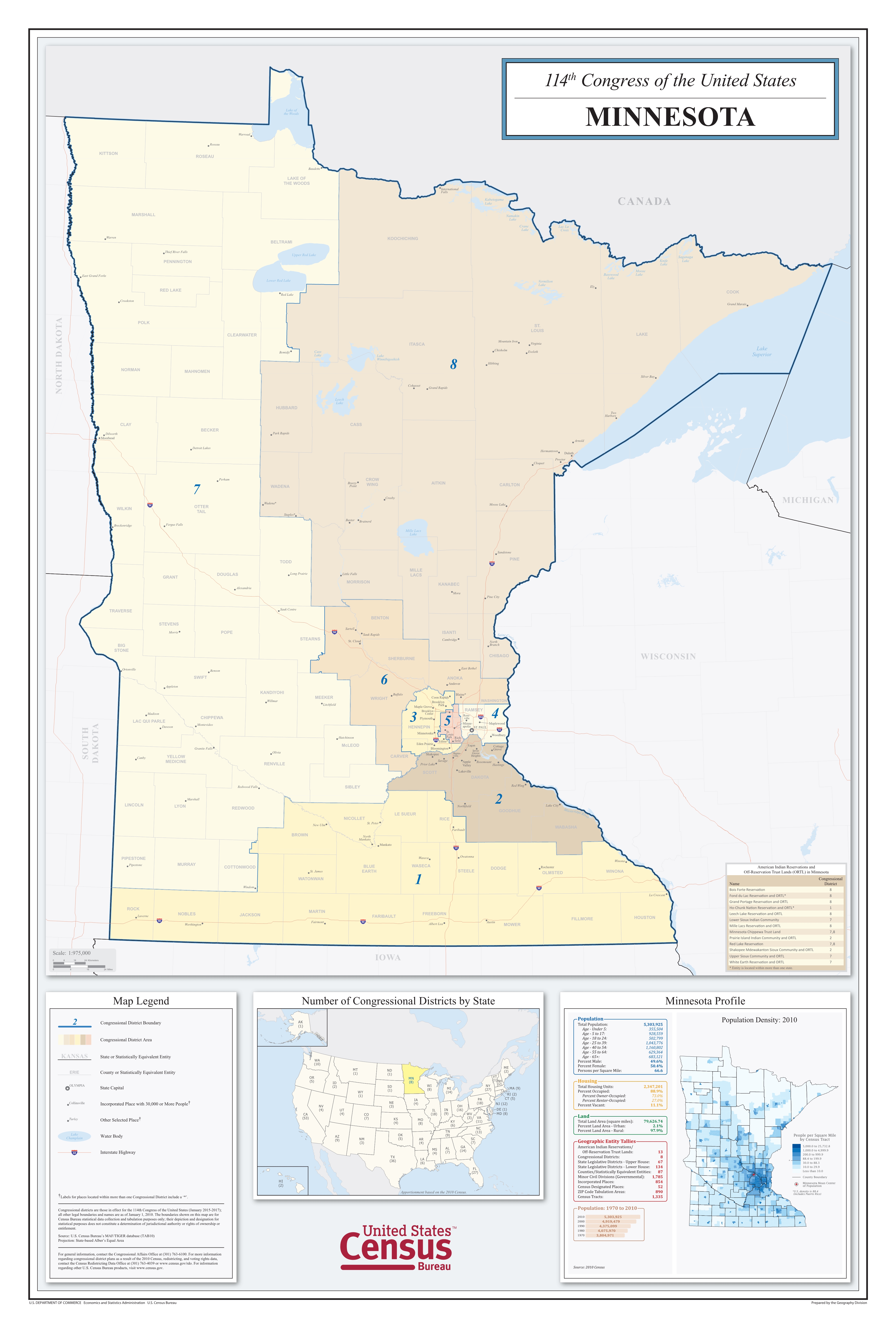
(Click to Enlarge)
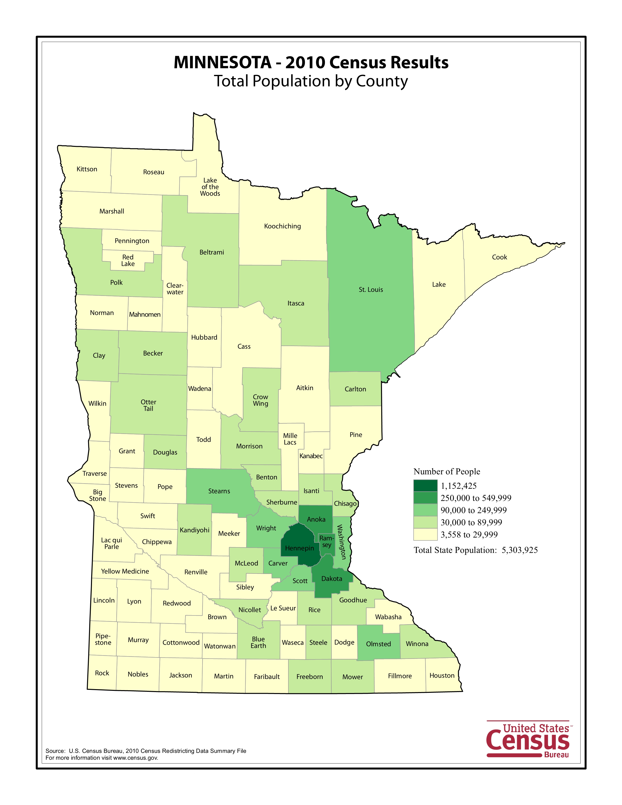
(Click to Enlarge)