Facts & Statistics
| STATE STATISTICS | |
| Population 2020 | 3,700,000 |
| Population 2019 | 3,565,287 |
| Population 2018 | 3,572,665 |
| Population 2017 | 3,573,880 |
| Population 2016 | 3,578,674 |
| Below Poverty 2019 | 10 |
| Below Poverty 2018 | 10.2 |
| Below Poverty 2017 | 9.6 |
| Below Poverty 2016 | 9.8 |
| Employment – Population Ratio 2019 | 63.9 |
| Employment – Population Ratio 2018 | 63.4 |
| Employment – Population Ratio 2017 | 62.8 |
| Employment – Population Ratio 2016 | 62.6 |
| Unemployed 2020 | 8 |
| Unemployed 2019 | 3.8 |
| Unemployed 2018 | 4.1 |
| Unemployed 2017 | 4.7 |
| Unemployed 2016 | 5.7 |
| Foreclosure Rate 2018 | 1 of 1,520 |
| STATE FACTS |
|---|
| The first automobile law was passed by the state of Connecticut in 1901. The speed limit was set at 12 miles per hour. |
| West Hartford is the birthplace of Noah Webster, the author of the first dictionary published in 1807. |
| Connecticut’s most important crops are dairy, poultry, forest and nursery, tobacco, vegetables and fruit. |
Government
| ELECTED OFFICIALS | |
| Governor | Ned Lamont (D) |
| Lieutenant Governor | Susan Bysiewicz (D) |
| Attorney General | William Tong (D) |
| Secretary of State | Mark Kohler (D) |
| State Senate Control | D – 23; R – 12 |
| State House Control | D – 97; R – 54 |
Legislative Process
| LEGISLATIVE DATES AND DEADLINES | |
| Convenes | January 12, 2022 |
| Sine Die Adjournment | May 4, 2022 |
| Committee Action Deadlines | N/A |
| Crossover Deadline | None |
| Carryover from Previous Session | No |
| Governor’s Signing Deadline (in session) | Five days, Sundays and legal holidays excepted |
| Governor’s Signing Deadline (after adjournment) | 15 days from presentment |
| Veto Override | 2/3 majority |
| Legislation Effective Date | The following October 1 |
Notable Laws & Legislation
SAFE Act
AFSA Comment Letters
- Connecticut HB 5490 – Demographic Data Acquisition (August 31, 2018)
Enforcement
Consumer Complaints
Regulatory Actions
Featured Regulations
Regulatory Guidelines
Opinions
Advocacy, Initiatives & Reports
Advocacy
- 33 States Amicus Brief re: Telephone Consumer Protection Act (March 2020)
- 23 State & DC Letter to FDIC re: “Rent-A-Bank” Predatory Lending (February 2020)
- 25 State & DC Letter to Education Department re: Student Loan Debt Relief (February 2020)
- 23 State & DC Amicus Brief re: Constitutionality of CFPB (January 2020)
- 20 State & DC Amicus Brief re: Public Student Loan Forgiveness (November 2019)
- 22 State Letter to Education Department re: Student Loan Forgiveness (November 2019)
- 21 State & DC Letter to HUD re: Housing Discrimination (October 2019)
- 29 State & DC Letter to Education Department re: Student Loan Fraud (October 2019)
- 12 State & DC Letter to CFPB re: Home Mortgage Disclosure Act (October 2019)
- 20 State & DC Letter to Congress re: Cannabis Banking (September 2019)
- 27 State & DC Letter to CFPB re: Debt Collection Rule (September 2019)
- 31 States & DC Amicus Brief re: Student Loans (August 2019)
- 11 States & DC Letter to Education Department re: Public Service Loan Forgiveness Program (August 2019)
- 31 States & DC Amicus Brief re: Student Loans (August 2019)
- 11 States & DC Letter to Education Department re: Public Service Loan Forgiveness Program (August 2019)
- 50 States & DC Letter to FCC re: Robocalls (August 2019)
- 40 States & DC Letter to FTC re: Data Privacy (June 2019)
- 50 States & DC Letter to Education Department re: Student Loans for Disabled Veterans (May 2019)
- 24 States & DC Letter to CFPB re: Payday Rule (May 2019)
- 33 States & DC Letter to Congress re: Marijuana Banking (May 2019)
- 41 States & DC Letter to FCC re: Robocalls (May 2019)
- 20 States & DC letter to Education Department re: Student Loan Disclosure to Law Enforcement (April 2019)
- 24 State & DC Letter to CFPB re: Payday Lending Rule (March 2019)
- 50 States & DC Letter to U.S. Senate Committee on Commerce, Science & Transportation re: Robocalls (March 2019)
- 30 States & DC Letter to FTC re: Identity Theft Rule (February 2019)
- 22 State AGs Letter to CFPB re: Regulatory Sandbox (February 2019)
- 14 State AGs Letter to FDIC re: Small-Dollar Lending (January 2019)
- 15 State AGs Amicus Brief re: Tribal Immunity for Payday Lending (December 2018)
- 43 State AGs Letter to Social Security Administration re: Identity Fraud (December 2018)
- 21 State AGs letter to Department of Education re: closed-school loan discharge regulations (October 2018)
- 33 State AGs letter to CFPB re: Military Lending Act (October 2018)
- 17 State AGs letter to HUD re: Affirmatively Furthering Fair Housing rule (October 2018)
- 35 State AGs Letter to Federal Communications Commission (FCC) re: Robocalls (October 2018)
- 11 State AGs letter to Department of Education re: Public Service Loan Forgiveness (PSLF) Program (October 2018)
- 16 State AGs Amicus Brief re: States’ Oversight on Student Loan Servicers (September 2018)
- 20 State AGs letter urging Secretary of Education to share student loan information with law enforcement (July 2018)
- 32 AGs letter urging Congress to preserve state’s authority to enforce data breach & security laws (March 2018)
- 30 AGs letter to Congress urging it to reject legislation that would block state oversight of student loan servicing industry (March 2018)
- 20 State AGs letter to Education Secretary re student borrower defense proposal (March 2018)
- 16 State & DC AGs brief calling on Trump Admin. to respect CFPB independence (February 2018)
- 18 State AGs urge Congress to incorporate cannabis industry into banking system (January 2018)
- 16 State AGs letter to President re CFPB (December 2017)
- Lawsuit opposing temporary CFPB director (December 2017)
- 43 State AGs Letter – Major Data Breach (September 2017)
- 8 State AGs Letter Supporting CFPB Proposed Small-Dollar Rule (October 2016)
- 18 States Letter to CFPB – Proposed Arbitration Rule (August 2016)
- 9 State AGs & DC Joint Letter to Financial Corporation CEOs – Chip and PIN Technology (November 2015)
- Final NAAG Data Breach Notification Letter (July 2015)
- 31 State AGs Letter to CFPB – Debt Collection Rules (March 2014)
- AGs from 19 States ask JPMorgan Details on 2014 Data Breach (January 2014)
Reports
Trade Associations
There are currently no partner industry associations in Connecticut


Political Geography

(Click to Enlarge)
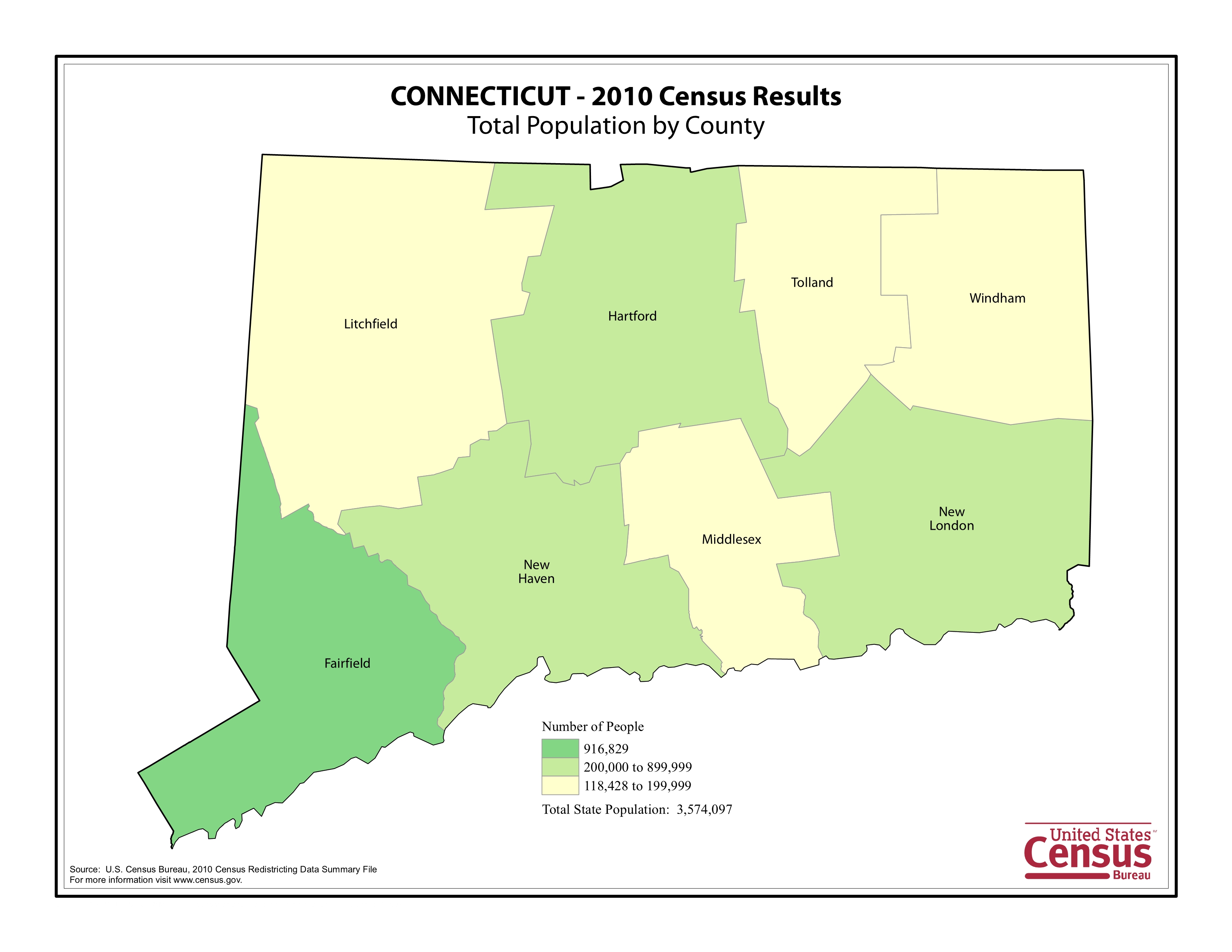
(Click to Enlarge)